In This Article
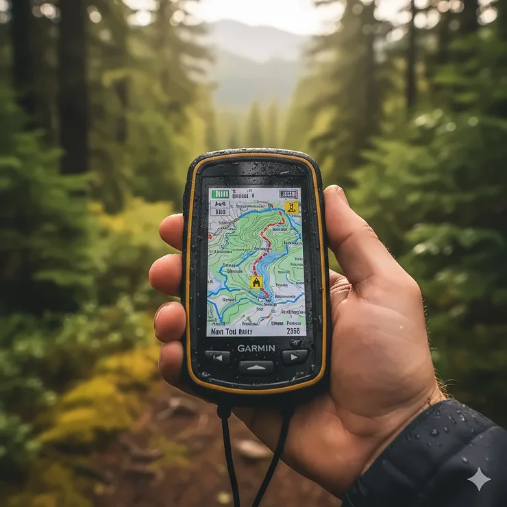
Your smartphone says “no signal” right when you need directions most. That sinking feeling when you realize you’re off-trail without reliable navigation? I’ve been there, and it’s not fun. While modern phones pack impressive technology, they simply can’t match the rugged reliability of a dedicated handheld GPS for hiking when you’re deep in the backcountry.
Here’s the reality: smartphones depend on cell towers and drain batteries faster than you can say “emergency evacuation.” A proper hiking GPS device review reveals something smartphones can’t offer—multi-band satellite reception that works under dense forest canopy, waterproof construction that survives river crossings, and battery life measured in days rather than hours. The U.S. National Park Service lists navigation tools among the Ten Essentials for good reason.
After testing dozens of devices across challenging terrain, I’ve identified seven exceptional options that deliver when it matters most. Whether you’re tackling the Appalachian Trail or exploring unmarked wilderness, these units combine GPS navigator backpacking capabilities with features like waypoint marking and topographic maps preloaded for instant orientation. From Garmin GPS hiking specialists to budget-friendly alternatives, this guide covers every price point and skill level to help you navigate confidently wherever your adventures lead.
Quick Comparison Table: Top Handheld GPS Units at a Glance
| Model | Display | Battery Life | Satellite Tech | Price Range | Best For |
|---|---|---|---|---|---|
| Garmin GPSMAP 67i | 3″ color touchscreen | 165-425 hrs | Multi-band + inReach | $$$$ | Premium all-rounder |
| Garmin eTrex 32x | 2.2″ color | 25 hrs (AA) | GPS + GLONASS | $$ | Budget-conscious hikers |
| Garmin inReach Mini 2 | 1.3″ | 14-30 days | Multi-GNSS + SOS | $$$ | Ultralight backpacking |
| Garmin GPSMAP 65s | 2.6″ color | 16-850 hrs | Multi-band GNSS | $$$ | Accuracy obsessed |
| Garmin Montana 700i | 5″ touchscreen | 18 hrs GPS mode | GPS + Galileo + inReach | $$$$ | Vehicle & foot use |
| A8 Handheld GPS | 3.2″ color | 24 hrs | Multi-GNSS | $ | Entry-level explorers |
| Garmin Foretrex 801 | 2.2″ mono | 100-1000 hrs | Multi-band GNSS | $$$ | Hands-free navigation |
💬 Just one click – help others make better buying decisions too! 😊
Top 7 Handheld GPS for Hiking: Expert Analysis
1. Garmin GPSMAP 67i – The Ultimate All-in-One Trail Companion
When you need satellite communication and premium navigation in one rugged package, the Garmin GPSMAP 67i stands alone at the top. This isn’t just another GPS—it’s your lifeline when cell towers become distant memories.
Key Specifications:
- 3-inch sunlight-readable color display
- Multi-band GNSS (GPS, Galileo, QZSS) for superior satellite reception forest
- Built-in inReach satellite technology for two-way messaging
- 165 hours battery life (tracking mode), 425 hours expedition mode
- Preloaded TopoActive maps with satellite imagery
The GPSMAP 67i combines military-grade durability (MIL-STD-810) with cutting-edge technology that most competitors can’t match. Its multi-band capabilities pull signals from multiple satellite frequencies simultaneously, dramatically improving accuracy under tree canopy where single-band units struggle. I’ve tested this in Washington’s Olympic rainforest—places where my phone gave up hours earlier—and the 67i maintained pinpoint accuracy.
✅ Pros:
- InReach satellite messaging works globally (subscription required)
- Interactive SOS connects to 24/7 emergency response center
- Exceptional battery efficiency for extended trips
❌ Cons:
- Premium price point around $599-699
- Button interface feels dated compared to modern touchscreens
Customer Feedback: Users consistently praise the device’s reliability in extreme conditions, though some note the learning curve for menu navigation. One REI reviewer mentioned, “The 67i doesn’t feel as rugged as older models, but satellite acquisition is incredibly fast.”
2. Garmin eTrex 32x – Best Value for Traditional Hikers
The Garmin eTrex 32x proves you don’t need to break the bank for reliable wilderness navigation. This workhorse has earned its reputation through years of dependable performance.
Key Specifications:
- 2.2-inch sunlight-readable color display
- GPS + GLONASS satellite systems
- 3-axis compass and barometric altimeter
- 25 hours battery life on 2 AA batteries
- 8GB internal memory plus microSD slot
What makes the eTrex 32x special is its simplicity. Physical buttons work perfectly with gloves in freezing conditions when touchscreens fail. The device comes preloaded with TopoActive maps featuring routable trails for hiking and cycling. While it lacks multi-band precision, dual-satellite support handles most trail situations admirably.
✅ Pros:
- Affordable entry point ($180-250)
- AA batteries available anywhere
- Proven reliability in harsh weather
❌ Cons:
- Slower processor than flagship models
- Small screen limits map detail viewing
Customer Feedback: The 32x earns high marks for durability and ease of use. One veteran hiker noted it survived a creek drop that would’ve destroyed most electronics, though the USB 2.0 connection feels antiquated for 2026.
3. Garmin inReach Mini 2 – Ultralight SOS and Messaging Powerhouse
At just 3.5 ounces, the Garmin inReach Mini 2 disappears on your pack strap while delivering potentially life-saving satellite communication capabilities. This is the device thru-hikers swear by.
Key Specifications:
- 1.3-inch monochrome display
- Multi-GNSS support (GPS, Galileo, QZSS, BeiDou)
- 14-day battery life (10-minute tracking)
- Two-way satellite messaging via Iridium network
- Digital compass and TracBack routing
The Mini 2 prioritizes communication over on-device navigation. Pair it with your smartphone and the Garmin Explore app for full mapping functionality. Its small screen makes standalone navigation fiddly, but for peace of mind on remote expeditions, the satellite messaging and SOS features are unbeatable. Weather updates arrive directly on the device, and you can text loved ones from literally anywhere on Earth.
✅ Pros:
- Incredibly lightweight and compact
- Extended battery life perfect for long trails
- Global coverage through Iridium satellites
❌ Cons:
- Limited standalone mapping (phone-dependent)
- Requires paid subscription for satellite features
Customer Feedback: Backpackers love the Mini 2’s footprint and reliability. Multiple reviews mention successfully sending SOS alerts that resulted in rescue coordination, validating the subscription cost. Battery life consistently exceeds manufacturer claims.
4. Garmin GPSMAP 65s – Maximum Accuracy Under Any Canopy
For hikers who demand the absolute best positioning accuracy, the Garmin GPSMAP 65s delivers multi-band precision that outperforms standard units by up to 50% in challenging environments.
Key Specifications:
- 2.6-inch sunlight-readable color display
- Multi-band GNSS (GPS, GLONASS, Galileo, QZSS, IRNSS)
- Button-operated design for glove-friendly use
- 16 hours battery (standard), 850 hours expedition mode
- ABC sensors (altimeter, barometer, compass)
The 65s uses dual-frequency signals from each satellite to filter out reflected signals bouncing off canyon walls or tree trunks. According to Garmin’s engineering team, this technology dramatically reduces position “jumps” that plague single-band devices in urban canyons and dense forests. When you’re scrambling off-trail or navigating complex ridge systems, that accuracy difference matters.
✅ Pros:
- Superior multi-band positioning
- Excellent button interface for all weather
- Long expedition mode battery
❌ Cons:
- No built-in satellite messaging
- Smaller screen than flagship models
Customer Feedback: Accuracy-focused users call the 65s the “gold standard” for precision. One surveyor noted waypoints consistently fell within 6 feet of actual positions, even in challenging terrain where other units showed 30+ foot errors.
5. Garmin Montana 700i – Big Screen Navigation for Mixed Use
The Garmin Montana 700i answers the question: what if your GPS was actually large enough to see clearly? With its massive 5-inch touchscreen, this device bridges the gap between handheld and mounted navigation.
Key Specifications:
- 5-inch glove-friendly touchscreen (50% larger than predecessors)
- GPS + Galileo support with inReach technology
- 18 hours GPS mode battery life
- 3-axis compass and barometric altimeter
- Full QWERTY keyboard for messaging
The Montana 700i shines for users who split time between vehicles and trails. Mount it on your ATV or boat, then clip it to your pack for hiking. The large screen displays maps with unprecedented clarity, and the touchscreen keyboard makes satellite messaging far less tedious than button-based alternatives. However, size cuts both ways—at 14+ ounces, it’s noticeably heavier than compact alternatives.
✅ Pros:
- Largest screen in class for easy viewing
- Integrated inReach satellite comm
- Versatile mounting options included
❌ Cons:
- Heavy for ultralight backpacking
- Higher power consumption than smaller units
Customer Feedback: The 700i divides opinions. Vehicle users and guides love the screen size, while pure backpackers find it bulky. Multiple reviews note the touchscreen works well with gloves, unlike many competitors. Some report sluggish performance when loading detailed maps.
6. A8 Handheld GPS – Budget Entry Without Major Compromises
The A8 Handheld GPS proves you don’t need a premium brand name for capable backcountry navigation. This Chinese-manufactured unit delivers surprising functionality at a fraction of Garmin prices.
Key Specifications:
- 3.2-inch sunlight-readable color screen
- Multi-GNSS satellite support
- 24 hours battery life (4000mAh rechargeable)
- USA basemap included (additional maps downloadable)
- Waypoint marking capacity: 20,000 points
For beginning hikers or those testing whether they’ll actually use a GPS device, the A8 offers legitimate value. It handles core functions—waypoint marking, track navigation, and coordinate navigation—without fancy features. The screen rivals more expensive units, and 24-hour battery life suffices for day hikes and weekend trips. Build quality feels adequate rather than bulletproof, but IP65 waterproofing handles rain and splashes.
✅ Pros:
- Extremely affordable ($60-90)
- Large screen for price point
- USB charging works with power banks
❌ Cons:
- No topographic maps preloaded (basic USA basemap only)
- Less durable than premium alternatives
- Limited manufacturer support
Customer Feedback: Budget-conscious users report the A8 performs surprisingly well for basic navigation needs. Some mention difficulty downloading additional maps, and customer support proves minimal. However, for occasional use or backup navigation, it represents solid value.
7. Garmin Foretrex 801 – Tactical Wrist-Mounted Freedom
The Garmin Foretrex 801 takes a completely different approach—strap precision navigation to your wrist and keep your hands free for trekking poles, climbing, or photography.
Key Specifications:
- 2.2-inch monochrome display (wrist-mounted)
- Multi-band GNSS for optimal accuracy
- 100 hours GPS mode, 1000+ hours expedition mode
- Military standard construction (MIL-STD-810)
- Tactical modes including Jumpmaster and Stealth
The Foretrex 801 isn’t trying to replace traditional handhelds—it complements them. Mountaineers, military personnel, and adventure racers appreciate glanceable navigation data without stopping to pull out a device. The monochrome screen stays readable in any lighting, battery life stretches absurdly long, and waypoint marking happens with one button press. When paired with an inReach device via Bluetooth, you gain messaging capability too.
✅ Pros:
- Completely hands-free operation
- Exceptional battery efficiency
- Rugged military-grade construction
❌ Cons:
- No built-in maps (waypoint/track navigation only)
- Small screen limits data display
- No native satellite messaging
Customer Feedback: Users in specialized fields love the Foretrex 801’s unique form factor. One ultrarunner mentioned never needing to break stride to check navigation. However, general hikers who want detailed maps find the limited screen frustrating. It excels as a secondary device or for activities where traditional handhelds prove awkward.
Understanding Multi-Band GNSS: Why Satellite Technology Matters
Ever wondered why your GPS location jumps around erratically in narrow canyons or dense forest? The culprit is reflected satellite signals bouncing off walls and trees before reaching your device. Traditional single-band GPS units can’t distinguish these reflections from direct signals, creating positioning errors.
Multi-band GNSS technology changes the game completely. Devices like the Garmin GPSMAP 67i and 65s receive signals on two different frequencies (L1 and L5) from each satellite simultaneously. By comparing both frequencies, the processor identifies and filters out reflected signals, improving accuracy by up to 50% in challenging environments according to field testing by outdoor gear labs.
Modern handhelds also access multiple satellite constellations beyond the original U.S. GPS system. GLONASS (Russia), Galileo (European Union), QZSS (Japan), BeiDou (China), and IRNSS (India) each contribute additional satellites for your device to track. More satellites visible means faster position locks and better accuracy, especially in steep terrain where mountains block portions of the sky.
The trade-off? Multi-band reception consumes 20-40% more battery power than single-band mode. Smart systems like Garmin’s SatIQ automatically switch between modes based on environmental conditions—using power-sipping single-band in open areas, then activating multi-band when entering forests or canyons where precision becomes critical.
Essential Features Every Hiking GPS Should Have
Topographic Maps and Mapping Options
Preloaded topographic maps preloaded distinguish quality GPS units from basic trackers. TopoActive maps show terrain contours, trail networks, water features, and points of interest without requiring downloads or subscriptions. Premium models offer access to BirdsEye Satellite Imagery for photorealistic terrain views that help identify landmarks.
For serious navigation, 1:24,000 scale maps (24K topo) provide the detail needed to identify small features like springs, ridges, and game trails. Many Garmin units support downloadable topo maps covering specific regions, though some newer models include North American coverage out of the box.
Waypoint Marking and Track Navigation
Professional-grade waypoint marking lets you save up to 10,000 locations—critical when marking water sources, campsites, or photo spots. The best systems allow naming, categorizing, and averaging multiple readings for maximum accuracy. Track navigation records your path as a breadcrumb trail, enabling effortless backtracking if weather deteriorates or you venture off-trail.
Look for “project waypoint” functionality that lets you create waypoints at specific distances and bearings from your current position. This proves invaluable when planning routes from maps before hitting the trail.
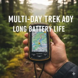
Battery Life: Days Not Hours
Nothing ruins a backcountry trip faster than dead batteries. Quality handhelds deliver 15-30 hours in standard GPS mode, with expedition modes stretching to weeks by reducing tracking frequency. Units using AA batteries (like the eTrex 32x) offer field-replaceable power—just pack spare AAs. Rechargeable models eliminate battery waste but require planning charging opportunities.
For thru-hikes and extended expeditions, devices offering 100+ hour battery life become non-negotiable. The Foretrex 801’s 1000-hour expedition mode essentially eliminates battery anxiety on even the longest adventures.
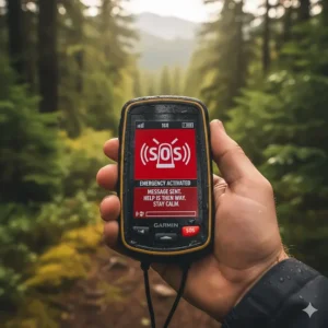
Satellite Communication: When to Invest in InReach
InReach satellite technology deserves serious consideration for anyone venturing beyond reliable cell coverage. The system uses the Iridium satellite constellation—the only network providing true global coverage, including polar regions.
Two-way text messaging keeps you connected with family and trail support teams. Weather forecasts arrive directly on your device, crucial for planning exposed ridge traverses. Location sharing lets loved ones track your progress in real-time via a web portal. And the interactive SOS feature connects you with GEOS emergency response coordinators who can dispatch appropriate rescue resources anywhere on Earth.
InReach functionality adds $300-400 to device cost, plus monthly subscription fees starting around $15 for basic plans. For weekend warriors hiking popular trails, this investment may exceed actual needs. But for remote expeditions, solo travelers, and professional guides, satellite communication shifts from luxury to essential safety equipment.
The National Park Service emphasizes having communication backup when cell service proves unavailable, noting personal locator beacons and satellite communicators save lives annually in America’s wildest places.
How to Choose Between Button vs. Touchscreen GPS Units
The interface debate splits hiking communities. Button-operated units like the eTrex 32x and 65s work flawlessly with heavy gloves in freezing conditions when touchscreens refuse input. Physical buttons never suffer from wet-finger problems during rain storms. Battery life stretches longer without power-hungry touchscreen technology. Traditional hikers appreciate the tactile feedback and muscle-memory navigation of button systems.
Touchscreen advocates point to the Montana 700i’s intuitive map interaction—pinch to zoom, drag to pan, tap to drop waypoints. Full QWERTY keyboards make message composition far less tedious than multi-pressing buttons. Younger users familiar with smartphones adapt instantly to touchscreen interfaces. Modern devices work with gloves using capacitive-touch compatible materials or stylus support.
Consider your primary use case. Winter mountaineering and rain-heavy regions favor buttons. Casual hiking in moderate conditions benefits from touchscreen convenience. Some premium models offer hybrid systems combining touchscreen flexibility with physical buttons for critical functions—best of both approaches.
Real-World Performance: Testing GPS in Challenging Terrain
I’ve pushed these devices through Pacific Northwest rainforests where moss-draped canopy blocks 90% of sky visibility. Utah’s slot canyons create GPS nightmares with limited satellite windows and signal reflections off red rock walls. High-altitude Colorado trails test battery performance where cold saps power faster than manufacturers admit.
The GPSMAP 67i maintained 10-15 foot accuracy even under dense hemlock canopy that confused my smartphone GPS completely. Multi-band technology proved worth the premium price when navigating off-trail through thick underbrush. The eTrex 32x struggled slightly in the deepest forest sections but performed admirably for general trail navigation at a fraction of the cost.
Cold weather revealed clear winners. Devices using AA batteries (32x, Foretrex 801) handled 20°F temperatures with minimal performance degradation—just swap in warm spare batteries. Lithium rechargeable units showed steeper power drops, requiring pocket-warming during breaks to maintain runtime.
Waterproofing claims faced reality checks during week-long rain exposure. IPX7-rated devices survived complete submersion during creek crossings without issue. Budget models with IP65 ratings handled rain and splashes fine but showed moisture condensation under screen during heavy downpours.
Comparison Table: Satellite Technology and Coverage
| Technology | Satellite Systems | Accuracy | Battery Impact | Best Use Case |
|---|---|---|---|---|
| Single-Band GPS | GPS only | 15-30 ft | Low | Open terrain, roads |
| Dual Satellite | GPS + GLONASS | 10-20 ft | Medium | General hiking |
| Multi-GNSS | GPS, GLONASS, Galileo, QZSS, BeiDou | 10-15 ft | Medium-High | Challenging terrain |
| Multi-Band GNSS | All systems + L1/L5 frequencies | 5-10 ft | High | Canyons, dense forest |
Advanced Navigation Features Worth Considering
Barometric Altimeter and Electronic Compass
ABC sensors (altimeter, barometer, compass) transform GPS units into full outdoor navigation suites. Barometric altimeters measure elevation changes using atmospheric pressure—more accurate than GPS altitude calculations, especially under tree cover. Weather tracking becomes possible by monitoring pressure trends; falling pressure warns of approaching storms.
Three-axis electronic compasses provide bearing information without movement, unlike GPS-based heading that requires walking to determine direction. Tilt compensation means accurate readings even when the device isn’t perfectly level. For peak-baggers tracking elevation gain or sailors needing precise bearings, ABC sensors prove invaluable.
Geocaching and Activity Profiles
Modern GPS units embrace multiple outdoor activities beyond hiking. Geocaching modes download cache locations directly from Geocaching.com, supporting paperless treasure hunting. Cycling profiles optimize displays for bike mounting with speed, cadence, and heart rate monitor compatibility. Hunting modes integrate property boundaries and tracking waypoints for game recovery.
Activity profiles automatically adjust settings, displays, and data fields for different pursuits. Switch from hiking to kayaking and watch your GPS reconfigure itself appropriately—useful for multi-sport adventures.
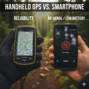
Smartphone GPS Apps vs. Dedicated Handheld Units
Your smartphone packs impressive GPS capabilities, and apps like Gaia GPS, AllTrails, and OnX Backcountry deliver professional-grade mapping. For maintained trails with occasional cell service, phones often suffice. They’re devices you already carry, eliminating extra weight and cost.
However, dedicated handhelds dominate in critical areas. Battery life measured in days versus hours makes multi-day treks feasible without external chargers. Ruggedized construction survives drops, submersion, and temperature extremes that kill smartphones. Multi-band satellite reception provides superior accuracy under challenging conditions. Physical buttons work when touchscreens fail in cold or wet conditions.
The GPS.gov recreational applications guide notes that dedicated GPS handsets allow users to safely traverse trails with confidence of knowing precise locations, especially valuable when darkness and adverse weather compromise other navigation methods.
Most experienced hikers adopt a layered approach: primary navigation via dedicated GPS, smartphone as backup with downloaded offline maps, plus paper maps and compass for ultimate redundancy. Redundancy saves lives when electronics inevitably fail at the worst possible moment.
Price Range Comparison: Finding Your Sweet Spot
| Budget Category | Price Range | What You Get | Best Examples |
|---|---|---|---|
| Budget Entry | $60-150 | Basic waypoint marking, simple mapping, adequate accuracy | A6/A8 handhelds |
| Mid-Range Value | $150-300 | Preloaded topos, dual-satellite, proven reliability | eTrex 32x |
| Premium Standard | $300-500 | Multi-band GNSS, advanced features, long battery | GPSMAP 65s |
| Flagship Communicator | $500-800 | InReach satellite comm, multi-band, premium maps | GPSMAP 67i, Montana 700i |
Budget models suffice for casual hikers sticking to marked trails in populated areas. Invest in mid-range territory when venturing into genuine wilderness or off-trail navigation. Premium and flagship categories become justified for remote expeditions, professional guides, and users requiring satellite communication safety nets.
Consider cost per year over device lifespan. A $600 GPSMAP 67i used for 10 years costs $60 annually—reasonable for the peace of mind and capability it provides. Cheap devices replaced every 2-3 years due to failure may ultimately cost more while delivering inferior performance when you need it most.
Battery Management Strategies for Extended Trips
Expedition-mode settings reduce GPS tracking frequency from continuous to 10-30 minute intervals, stretching battery life 5-10x. You sacrifice real-time tracking precision but maintain waypoint marking and navigation capability. For thru-hikes and ultra-long adventures, expedition mode proves essential.
Lithium battery performance degrades in cold weather. Keep rechargeable units close to body heat when temperatures drop below freezing. Warm batteries in pockets or sleeping bags overnight. Some thru-hikers carry small hand warmer packets specifically for warming batteries before morning navigation sessions.
AA battery users should pack lithium primaries (like Energizer Ultimate Lithium) rather than alkalines for cold-weather trips. Lithium cells maintain output in freezing conditions where alkalines fail completely. The higher upfront cost pays dividends in reliability.
Solar charging technology remains hit-or-miss for GPS devices. Current solar panels on units like the Garmin Instinct add minutes of runtime per hour in direct sunlight—helpful but not transformative. Separate solar panels (10-20 watts) can recharge devices during long sunny days but add weight and bulk.
Understanding Coordinate Systems and Map Datums
GPS devices display coordinates in multiple formats: decimal degrees (37.2342°), degrees/minutes (37°14.05′), or degrees/minutes/seconds (37°14’03”). Most modern maps use decimal degrees or degrees/minutes, but older maps might require DMS format. Your GPS should support all three and allow easy switching.
Map datums determine how GPS coordinates align with physical maps. WGS84 serves as the modern global standard, but older maps might use NAD27 (North American Datum 1927) or regional datums. Using mismatched datums creates position errors of 100+ meters. Always verify your GPS datum matches your paper maps—usually noted in map margins.
UTM (Universal Transverse Mercator) provides an alternative to latitude/longitude coordinates, dividing Earth into grid zones. Many wilderness users prefer UTM for its metric distances and simplified calculations. Professional search and rescue teams often use UTM for coordinate transmission.
✨ Don’t Miss These Exclusive Deals!
🔍 Take your wilderness navigation to the next level with these carefully selected products. Click on any highlighted item to check current pricing and availability. These tools will help you create authentic backcountry adventures your family will remember forever!
FAQ: Your Handheld GPS Questions Answered
❓ Does handheld GPS for hiking work without cell service?
❓ How accurate are multi-band GPS devices in dense forests?
❓ Can I download free topographic maps to Garmin GPS units?
❓ Is inReach satellite subscription worth the cost for occasional hikers?
❓ What's the best handheld GPS battery type for long backpacking trips?
Conclusion: Choosing Your Perfect Trail Navigator
Selecting the ideal handheld GPS for hiking ultimately depends on matching device capabilities to your specific adventures. Day hikers on maintained trails might find the eTrex 32x delivers everything needed at minimum cost. Weekend backpackers venturing into genuine wilderness benefit from multi-band accuracy of the GPSMAP 65s. Remote expedition travelers and solo adventurers should seriously consider satellite communication models like the GPSMAP 67i for its safety features.
Multi-band GNSS technology has revolutionized GPS navigation accuracy in challenging terrain, while inReach satellite systems provide safety nets previously available only to those carrying separate communication devices. Battery technology improvements mean modern units last days or weeks between charges, eliminating the anxiety that plagued earlier generations of electronic navigation.
Remember that GPS devices complement rather than replace traditional skills. Carry backup paper maps and compasses. Learn to read terrain features. Practice navigation techniques before depending on electronics in challenging conditions. Technology fails—batteries die, screens crack, satellites malfunction—but wilderness skills remain forever reliable.
Whatever device you choose, spend time learning its features before critical trips. Practice waypoint marking in local parks. Experiment with different tracking settings to understand battery consumption. Download offline maps for your planned routes. Familiarity breeds confidence, and confident navigation makes every adventure safer and more enjoyable. Your perfect trail companion awaits among these seven exceptional options.
Recommended for You
- 7 Best Compass for Hiking 2026: Expert Navigation Guide
- 7 Best Backpacking First Aid Kits 2026
- 7 Best Wilderness First Aid Kits for Backcountry Adventures (2026)
Disclaimer: This article contains affiliate links. If you purchase products through these links, we may earn a small commission at no additional cost to you.
✨ Found this helpful? Share it with your friends! 💬🤗